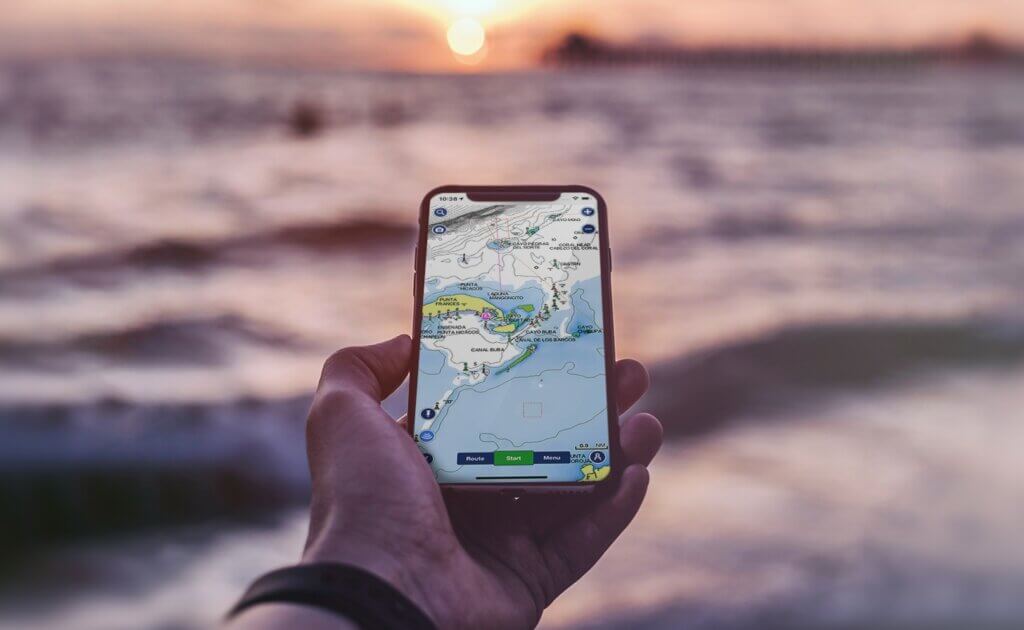
For recreational boaters, having accurate navigational information right at your fingertips can make a world of difference for staying safe and having more enjoyable time on the water. That’s where the Navionics Boating app comes in handy! As a trusted name in marine and lake charts and data, Navionics provides an essential app for mariners.
What is the Navionics Boating App?
The Navionics Boating app provides complete nautical mapping and navigation capabilities via mobile device. It gives boaters constantly updated charts, navigation tools, weather data, and other features for planning trips and navigating confidently.
Available on iOS and Android, the free app comes preloaded with basic worldwide charts. For full functionality, users purchase subscriptions to access more detailed chart regions, advanced planning features, and real-time data overlays.
With Navionics charts and navigation capabilities in your pocket, the Boating app aims to make getting out on the water safer and more enjoyable.
Why is Navionics Boating a Popular Choice?
Trusted Accuracy

Navionics’ charts and data are highly regarded for detail, currency and accuracy. The navigation features integrate fully with the chart data.
Real-time Capabilities
Overlays like AIS vessel positions, weather, tides and currents are updated live for situational awareness.
Powerful Route Planning
Build multi-leg routes with waypoints driving navigation right from your phone.
 RayView
Handy Fishing Tools
Mark hot spots, identify species, and record catches at various spots.
Premium Features
Unlock top-of-the-line capabilities with premium chart subscriptions.
Backed by one of the leading names in marine data, Navionics Boating is a go-to choice among saltwater and freshwater captains. The robust feature set enhance both planning and real-time piloting.

Key Benefits of Using Navionics Boating
From weekend cruisers to hardcore anglers, the Navionics Boating app offers compelling benefits:
Detailed Offline Charts
Download enhanced vector charts for your region to navigate even without signal.
Real-time Navigation Assistance
Track your boat on charts and easily synchronize routes and waypoints.
Vessel Traffic Overlay
View nearby AIS-equipped ships for collision avoidance and situational awareness.
Weather and Tides Data
Check current or forecasted weather and tidal information for your location.

Fishing Features
Use community data and personal logs to identify promising fishing hotspots.
Quick Access
All your essential navigational tools readily available on your mobile device.
For both planning and live piloting, the Navionics app places powerful assistance in the palm of your hand.
Features of the Navionics Boating App
Let’s explore some of the key features that make the Navionics Boating app such an indispensable tool:
Nautical Charts and Maps
At the core are downloadable vector charts covering coastal regions worldwide. Premium options include 1 foot bathymetry maps packed with depth data.

Real-time Navigation
Sync routes and waypoints between devices. Track your location via GPS with grounding warnings.
Weather and Tide Forecasts
View predictions for wind, waves, precipitation and water levels at your location.
AIS Integration
Connected to an AIS receiver, see live transponder data from commercial vessels near you.
3D Chart Views
Display your surroundings in a virtual 3D view from different perspectives.
Fishing Tools
Hot Spots overlay and journal with catches, conditions and photos at various markers.
Remote Control
Drive a compatible autopilot directly from the app via bluetooth connectivity.
Photos & Maps Integration
Overlay geotagged photos. Access additional map layers like satellite or terrain views.
Route Sharing
Share saved routes with friends via email, messaging and social media.
Using the Navionics App for Route Planning
Thorough route planning with Navionics allows previewing courses and identifying potential hazards before ever leaving the dock:
- Download charts to access offline during planning.
- Plot waypoints & routes for your intended course and destinations.
- Add navigation lines between waypoints.
- Measure distances and estimate time to traverse legs.
- Add annotations for points of interest, landmarks, hazards.
- View tides data to plan around currents.
- Check weather forecasts to prepare for expected conditions.
With routes locked in on Navionics charts ahead of time, navigating when underway becomes simplified.
Navigating Safely with Navionics
While on the water, Navionics Boating provides real-time guidance to pilot safely along your planned route:
- Monitor your boat icon moving across the charts to track your position.
- Follow suggested navigation lines and steering guidance to stay on course.
- Sync waypoints & routes wirelessly from your planner.
- Get alerts if your vessel nears charted hazards or shallows.
- Orient the map in track-up mode to align with your heading.
- View nearby AIS vessel transponder data to see ships’ speed, heading, size and name.
- Check the radar overlay to visually identify approaching rain and storms.
- Adjust your course to accommodate changing winds, tides or currents.
The app combines pre-planning with real-time data for safe navigation in congested or challenging areas.
Finding the Best Fishing Spots
Beyond navigation, Navionics Boating also excels at helping anglers discover promising new fishing locations:
- View community data on popular species and successful techniques by area.
- Check the SonarCharts layer for high-detail bathymetry.
- Identify contours, flats, drop-offs that appeal to target fish.
- Access curated hotspots with notes from fellow anglers.
- Record your own fishing journal entries for catches, conditions and tips.
- Save and organize custom markers for proven spots to revisit.
- Share updates and receive notifications when new data is added nearby.
The social fishing capabilities help uncover hidden honey holes and patterns for targeting trophy fish.
Using Weather & Tide Overlays
Navionics integration of weather and tide data allows preparing for conditions ahead:
- View forecasted tides at launch site to time your trip.
- Check current wind and wave data along route.
- See periods of rain or lightning approaching your position or waypoint.
- Identify areas with stronger currents to transit safely.
- Use predicted tide change timing to hit a spot on the optimal drift or bite.
- Avoid navigating shallows during extreme low tide periods.
- Return to protected waters if high winds are forecasted.
Optimizing your outings around weather and ocean conditions can make for more comfortable and productive time on the water.
Tips & Tricks
Here are some top techniques for new users unlocking the full potential of Navionics Boating:
- Use it for trip planning at home with wall charger before hitting the water.
- Create route alternatives in case conditions necessitate changing plans mid-trip.
- Back up saved hotspots, routes and tracks regularly in case of lost phone.
- Take screenshots to easily share fishing spots, hazards and points of interest with others.
- Adjust map perspectives for optimal views (North-up, 3D, etc).
- Use iPhone’s water lock mode and lanyard to prevent drops overboard.
- Carry power bank for longer trips if your phone battery tends to drain quickly from use.
- Report any needed chart corrections to Navionics to help improve accuracy.
Take full advantage of all Navionics has to offer for next-level navigation and fishing aid right in your pocket.
Conclusion
With its robust navigational capabilities, real-time data integration, and angler tools, the Navionics Boating app provides an invaluable companion for marine excursions. Whether you’re navigating congested harbors with sizeable commercial traffic or angling to hook the catch of a lifetime, Navionics equips you with the information needed for safe, efficient, and fun trips on the water.
So download Navionics Boating and unlock the charting and data power of one of the most trusted names in marine navigation. No matter what adventures you have planned on your next voyage, this app will prove an essential ally along the way!